Showing posts with label Killeagh. Show all posts

Cork114

Preview of the Mount Uniacke 5km race...

Location....A lot of runners may not have heard of Mount Uniacke but it's relatively easy to get to. It is located approx 3 miles to the north of the town of Killeagh in East Cork.


At the eastern end of Killeagh on the N25 road, there is a turn off at the bend of the road. See below...the road for Mount Uniacke is between the Thatch Pub and the local church. Mount Uniacke is 3 miles / 5kms up this road.

Mount Uniacke is tiny and consists of just a few buildings, two of which are pubs. As you can see below, when you enter Mount Uniacke from Killeagh, the race HQ is on the left.

This is the view as you enter Mount Uniacke. The finish line is outside the front of Hickey's Pub while the race HQ is behind the pub.

Another view...there is an open area behind the pub which will have a marquee as race HQ.


Course map...The race starts about 400m from Mount Uniacke. You then run back into Mount Uniacke and so a clockwise loop. You pass the start line again before going to to finish outside the pub in Mount Uniacke.

Profile.....This is the profile of the course. Not completely flat but nothing too serious either.

Course description....The race starts about 400m south-east of Mount Uniacke on the most direct road to Youghal. As you can see, it's reasonably flat and narrow.

At about 300m, you join the road from Killeagh to the left. As you can see, Mount Uniacke is straight ahead.

Important point! Note that the finish line is just around the corner on the left so be prepared for that at the end. For now, it's about 0.25miles and you stay right.

Staying right at the Y-junction with the hand pump.

The turn off for Inch is just up ahead to the right, roughly the 0.35 mile mark.


Once you turn off right, you have a gradual climbs up to the highest point of the course. This is the view around the half mile (800m) mark....quiet road with a gradual rise. From Mount Uniacke, the ascent is about 30m or 100ft.

At about 0.7 miles, you hit the highest point of the course and it's downhill straight away. This should be a very fast section.

One of the notable features on the race route is Inch National School. This is the view as you pass the the 1 mile mark with the school just ahead.

At about 1.1 miles just after you pass the school, the road veers to the right...

...and almost straight away, you turn right again onto a narrow country road. The village of Inch with its church and community centre is down the steep hill to the left. Ideally the race would have been held there but there are just too many steep hills.

This next section has a few bends at the start but has some nice long straight parts as well which are by and large gradually downhill.

Just after the 2 mile mark, you come to the Mount Uniacke to Youghal road and here you turn reight for home...

This is another view of it. This is the lowest part of the course and the road has been mostly downhill to get here and from here on, it's a gradual climb. It's one mile from here to the finish.

 The last mile starts pretty easy but it has a steep section from 2.4 to 2.6 miles. After that, it's past the start line, past the Killeagh road junction and onto the finish. Again, remember that it's just around the corner.


Overall......A reasonable 5k course with some hills. Nice quiet country roads with little traffic. Just north of Killeagh so easy to access.

Cork111

Preview of the Killeagh 4 mile road race...

The village of Killeagh is located in east County Cork on the N25 Cork-Waterford road. It is approximately 32 kilometres from Cork city and 10 kilometres west of Youghal.


The race HQ is at the Killeagh GAA grounds where there are changing and shower facilities. The entrance is where the 4 mile mark is shown on the map below.

As you approach Killeagh from Cork City / Midleton, the N25 road goes over an old railway bridge. About 100 metres after this, you take the first left...at the graveyard...see below...


After about 400m on this narrow road, you come to the entrance to the GAA grounds on the right...

The 4 mile course takes in a loop to the west of Killeagh. The first two miles are on the Killeagh - Mogeely road while the return journey is a much quieter narrow road.


This is the profile of the course. It can be broken down into three thirds. The first third is mostly uphill, the second third is mostly downhill and the last third is mostly flat.


Course description......Note that on the map showing the location of the GAA grounds, there is a small path going from the grounds and through a local housing estate. You can use this to get to the start line, there is no need to go out to the main road.

The 4 mile course starts close to the main road. As you can see below, it's pretty flat.


After about 400m, you reach the edge of Killeagh and begin a gradual climb...

After about 800m, you come to the junction shown below. It kind of shows what the hill is like. The road up to the right shows the climb out of the valley whereas the actual course which is straight ahead skirts the lower slopes of the hill. There is some climbing but nothing major.


At about 0.7 miles, you have done most of the climbing and now there are some gentle rises and falls as the road follows the contours of the side of the hill. At about 1.4 miles, you reach the highest point of the course near this junction......

After this, there is a nice fast downhill section...

Near the 2 mile mark, you leave the Mogeely road and turn off left onto a narrow country road...

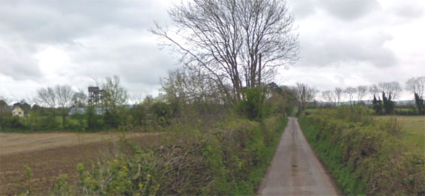
As you can see, it's pretty narrow and slightly downhill. One of the features you will notice along the route is the prominent water tower which is shown below on the left. This can be seen from several points along the course.

The corner at about 2.3 miles and about as close as you'll get to the tower. The road after this is pretty flat.

Bend at 2.6 miles....perfect road for a road race...nice and quiet....

At about 3.1 miles, you come to what was an old railway crossing. The Cork to Youghal railway line opened in 1860 and regular passenger services ran on it until February 1963. In the following 19 years, it was used for occasional summer excursions and goods traffic. It closed in August 1982.


After this, it stays pretty flat. After a dog bend at 3.4 miles, the course turns north-east and at 3.8 miles, you cross the old railway line again.


After going up and over the bridge, you'll see Killeagh in the distance...

The finish line is at the entrance to the GAA grounds. Once you see the 60kph signs in the distance then you'll know the finish line is just beyond it.

Overall......Some climbing early on but at least it's in the initial stages when you're not tired. Plenty of downhill and flat running. It should be a pretty fast 4 mile course. The last two miles of the course are on nice quiet country roads.