Showing posts with label 10 mile. Show all posts

Tipperary012

Preview of the Ballynonty 10 mile road race...

Location.....The village of Ballynonty is just 10.5 kms / 6.5 miles from the M8 motorway...

See map & photos below.....From the motorway, take exit 6....drive 800m to the T-junction in Horse & Jockey where you turn left...You are now on the old Cork-Dublin road. Drive up this road for 1.9 kms / 1.2 miles and take a right onto the L4101 (signposted for Killenaule which is just to the south of Ballynonty). Keep driving straight for 7.8 kms / 4.9 miles and you'll end up in Ballynonty.

Left at the T-junction in Horse & Jockey

Right at the next junction which is signposted for Killenaule

Closer look at Ballynonty....See map & photos below...As you approach from the direction of the Horse & Jockey, you'll pass the finish line of the race just before you come to a crossroads in the village. Drive straight through and 140m on the left, you'll see the local community centre which is in an ordinary residential house. This is the race HQ.

View of the crossroads as you arrive from the direction of Horse & Jockey. Drive straight through.

Ballynonty Community Centre is 140m from the crossroads in the village

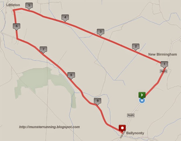
Course Map.......

Profile....

Course description.......The race starts about 0.8 miles from the village of Ballynonty. Most runners use this as part of their warm up for the race. The photo below shows the start area. The road is flat and not actually uphill. Considering the numbers that usually take part in this race, no time is lost at the start line.

The road for the first 0.7 miles is reasonably level until you approach New Birmingham. There is a gradual climb about 600m long here. Coming so early in the race, it's not a major issue even though it's the toughest part of the course.

You pass the 1 mile mark going uphill. The photo below shows the view from the next junction as you come up the hill and then turn left. As the photo shows, you have a rapid descent almost straight away from the junction...

Downhill view...

The road levels off close to the 2 mile mark when yo start passing some bog cuttings...

View at the road junction at 2.8 miles...still flat and straight....

There are a few small pulls along this section but they tend to be pretty short. In the whole, it's mostly a very fast section.

You pass the 5 mile mark as you approach Littleton...

At around 5.4 miles on the edge of Littleton, you take a left and head south...

Almost straight away, you are leaving Littleton behind as you head back out into the countryside as you pass Ballybeg Castle around 5.6 miles...

The road continues much the same as before...level and straight. At about 6.2 miles, you join the road from Horse & Jocket to Ballynonty...

Note! This is probably the busiest road on the course and the road is not closed to traffic. It usually isn't that heavy but you should be aware of passing traffic and stay to the side of the road.

The road along this stretch is different in that the road now has a number of short pulls. At around the 7.5 mile mark, the gradient increases slightly.

They hardly merit the description of hills as they are so short. The photo below show one just as you enter the outskirts of Ballynonty. It's perhaps 100m or so in length and the rise in elevation is perhaps only a few metres. Really nothing that anyone would consider serious.

The finish line is about 50m before the crossroads...

Overall........A reasonably fast 10 mile course. It certainly wouldn't be considered slower than the likes of say Dungarvan or Ballycotton. The most significant hill comes early on and there is plenty of flat and fast running for the rest of the race.

Organised by Ballynonty AC, it could probably be best described as a 'back to basics no frills race'. i.e. Accurate course with a very modest entry fee.

Cork068

Preview of the Clonakilty 10 mile road race...

This race is organised by Clonakilty Road Runner AC.

Location....Clonakilty is located some 40 kms to the south-west of Cork City...


Map of the start/finish area...The start and finish area is at the Model Railway Village on the road to Inchydoney...


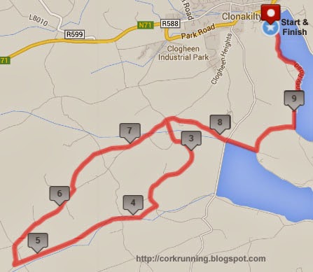
Map of the course...


Course Profile...


Course description....The race starts in at the Model Railway Village on the edge of the town of Clonakilty...


 ...and heads south alongside the bay...

At 1.6 miles, you leave the road to Inchydoney and you turn right over the causeway...

At the far side at 1.9 miles, you come to a crossroads...

The course goes across the junction and onto a quiet country road.  It remains more or less flat with one very short downhill section.

At 2.5 miles, you come to another crossroads. This is the start of the loop on the 10 mile course...

On the way out, you turn left. As you can see from the photo, on the way back you'll be running downhill to this junction and retracing your steps home.

You continue on a narrow country lane until you turn right into the uphill section around 3.7 miles...

This section is a gradual ascent of about 45 metres in height over about 1.5 miles. The steepest section tends to early on while the gradient becomes a lot gentler later on. As such, it's not really that bad and you shouldn't lost much time on it.

At 5.2 miles, you meet the road from Clonakilty to Rathbarry. If you are familiar with the Clonakilty Marathon route then you'll know that you have been running on it since the start. At this point, the marathon would proceed downhill towards Rathbarry. The 10 mile route however turns right and heads for home..

The road now continues to climb with about 20 metres in height gained over the next 0.8 miles until you reach the 6 mile mark, the highest point of the course...

Now for the fastest part of the course as it descends roughly 60 metres in height over the next 1.2 miles. It ends when you cross a stream at 7.2 miles and a short climb on the other side...

The climb is only about 200m long as no sooner have you reach the top of it when you beging the decent to the crossroads at 7.4 miles where you were earlier on in the race...

From here, you retrace your steps back to the finish line by the Model Railway Village.

Overall...Nice scenic course. About 2.3 miles of gradual climbing followed by 1.2 miles of descent. Possibly not the fastest of 10 mile courses but a lovely spot for a race.

Cork058

Preview of the Mealagh Valley Ring 10 mile road race...

The Mealagh Valley is located in the hills to the north-east of the town of Bantry in West Cork.

Getting there...The best way to find the Mealagh Valley is from Bantyr itself regardless of what direction you are coming from. If you are travelling from say near Cork City then you need to allow plenty of time to get to Bantry....say 1h 30m and then another 15 mins or so to get to the parking area.

The easiest way to get there is probably via Bandon....Enniskeane....Dunmanway....Drimoleague....Bantry.

Directions from Cork City on the N71 : When you arrive in Bantry, follow the road for Glengarriff to the outskirts of the town and past Caseys filling station. Take the next right at Donemark Bridge...see photo below.

Once you turn off right, you stay on this narrow road for about 8 kms. Just keep going straight.

Directions from Glengarriff & Kerry on the N71 : As you approach the outskirts of Bantry, follow the N71 passing the golf club on the right. After a long bend in the road, take the next left and follow the road as above. See photo below.


See photos near Donemark Bridge...

As you approach the race venue, you will meet some race stewards. Follow their directions for parking.


Entries........These are normally taken at Cronin's Yard. The community hall where the prizes and refreshments will be later is about 900 metres away...a 10 minute walk.


Please note! There is no need to go to the community centre before the race. Cronin's Yard is approx 200 metres from the start line.

Course map...

Course...The Mealagh Valley is a lovely quiet scenic spot for a race. It does however come at a price in that the course is very hilly. It's certainly not a race to set a 10 mile PB but it should be considered as more of a challenge.

The start is on a narrow road as shown above but with the reasonable small numbers, that's not really an issue. You're straight into a hill from the start as you run up a slight hill and past the entrance to Cronins Farm.

From there, the road drops rapidly on the other side into a long downhill section. At the end, the road twists and turns in a series of short uphill and downhill sections until you come to the community centre.

Note that the finish line is just outside the centre. When you are finishing the race, you will be covering this part of the course again.

But first time around, you keep going! Past where the finish line will be and into another downhill section until you get to a narrow bridge over the Mealagh River which gives the valley it's name.

This is the lowest part of the course and just after the bridge, you come to the 1 mile mark. From here, the next 600 metres or so are really tough. It's all uphill but it changes from gradual to short steep secions and back again. The hardest part of the course is just before you reach the local primary school.....

If it looks steep then that's because it is! This is a really steep section but it's pretty short. At the top, you join another road...

The road now changes into a relatively flat section which will give you a chance to recover from all of that climbing. You are basically running along a road above the valley floor with a nice view of the surrounding area. It's not that the road is dead flat or anything like it but it is easier than the initial two miles. As you head up the valley, the road climbs but starts to drop after the 5 mile mark as you come to the next road junction...

From here, you are heading back down the valley again with views of the mountains of the Beara Peninsula way off in the distance. You might think at this stage that since you are heading back down the valley, it might get easier. Dream on! You get to around 7 miles and there is another long hill. Nothing drastic but still slow going.

Eventually, you get some fast downhill sections...

...and you eventually turn left and retrace your footsteps from the start towards the finish line.

Overall.....It's probably the toughest 10 mile road race in the country but it's a great spot when the weather is nice. Not a course for personal best times but it's still a little gem. Quiet, scenic and rural. As the organisers say, it's got everything except flat sections ;o)