The Mealagh Valley is located in the hills to the north-east of the town of Bantry in West Cork.

Getting there...The best way to find the Mealagh Valley is from Bantyr itself regardless of what direction you are coming from. If you are travelling from say near Cork City then you need to allow plenty of time to get to Bantry....say 1h 30m and then another 15 mins or so to get to the parking area.
The easiest way to get there is probably via Bandon....Enniskeane....Dunmanway....Drimoleague....Bantry.
Directions from Cork City on the N71 : When you arrive in Bantry, follow the road for Glengarriff to the outskirts of the town and past Caseys filling station. Take the next right at Donemark Bridge...see photo below.
Once you turn off right, you stay on this narrow road for about 8 kms. Just keep going straight.
Directions from Glengarriff & Kerry on the N71 : As you approach the outskirts of Bantry, follow the N71 passing the golf club on the right. After a long bend in the road, take the next left and follow the road as above. See photo below.


As you approach the race venue, you will meet some race stewards. Follow their directions for parking.
Entries........These are normally taken at Cronin's Yard. The community hall where the refreshments will be later is about 900 metres away...a 10 minute walk.

Please note! There is no need to go to the community centre before the race. Cronin's Yard is approx 1.3kms from the start line.
Course map...
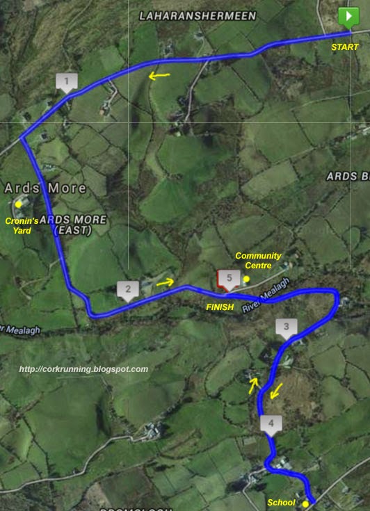

The start is on a narrow road but with the reasonable small numbers, that's not really an issue. You're straight into a downhill section from the start...

...until the first junction at about 1.2kms where you turn left.
From the junction, you run up a slight hill and past the entrance to Cronins Farm.The road then drops rapidly on the other side into a long downhill section (see photo).

At the end, the road twists and turns in a series of short uphill and downhill sections until you come to the community centre.
Note that the finish line is just outside the centre. When you are finishing the race, you will be approaching this point again but from the opposite direction.

Past where the finish line will be and into another downhill section until you get to a narrow bridge over the Mealagh River which gives the valley it's name.

This is the lowest part of the course. From here, the next 600 metres or so are really tough. It's all uphill but it changes from gradual to short steep sections and back again. The hardest part of the course is just before you reach the local primary school.....

If it looks steep then that's because it is! This is a really steep section but it's pretty short. At the top, you reach the turn around point and you retrace your steps to the finish line outside the community centre.
Overall.....It's probably the toughest 10 mile road race in the country but it's a great spot when the weather is nice. Not a course for personal best times but it's still a little gem. Quiet, scenic and rural. As the organisers say, it's got everything except flat sections ;o)